Report to Hikers May 15 – May 21

Wednesday May 17

Fischer Old Growth Natural Area, Newfield

Hike report by Jack V.

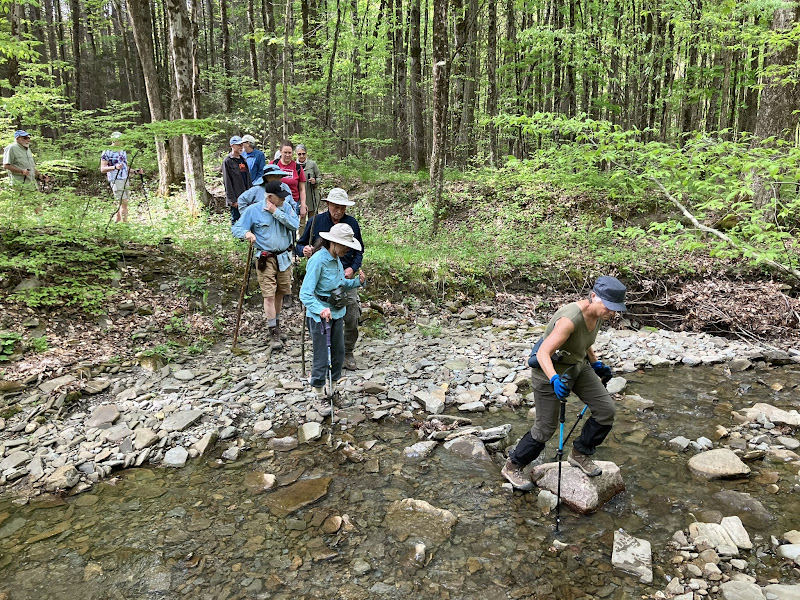
Twelve hikers plus one dog hiked the Fischer Old Growth Natural Area. It was a cool but pleasant day. The trails have changed since we last hiked there, and they were in great condition!

We hiked the red loop trail twice, once in each direction, and all of the other trails once. There was much elevation gained and lost in the almost four-mile hike.

A warm welcome to new hiker Shufang!

Photos by Jack V.

Photos by Leigh Ann

View Leigh Ann’s photo album.

Saturday May 20

Dryden Rail Trail

Hike report and photo by Jim

Twenty-five hikers and a single dog met on the solar farm service road off Stephenson Road for a hike of the Dryden Rail Trail and nearby Rabbit Run trail.

The first part of the rail trail has had some recent work done to it, likely in preparation for today’s ceremony officially marking the connecting of the East Hill Rec Way and the Dryden Rail Trail. The section we hiked today has recently had gravel dust laid down and compacted between the trailhead and Mount Pleasant Road. There’s also been some tree cutting and other trail maintenance performed. Despite the scheduled trail opening ceremony, we ran into relatively few others in the area.

The group passed over the FX Fox bridge, the crusher run rocks there crunching under our feet. We reached some residential development along the rail trail and detoured into the woods, where we joined the orange-blazed Rabbit Run trails. We hiked through the woods to the Rabbit Run Road parking area, finding little in the way of mud or blowdowns along the way. The line of hikers had become fairly spread out, so a quick stop for photos on this stretch was a good chance for us to regroup.

Once past Rabbit Run Road, we rejoined the trail system and hiked along the creekside. We had done this hike relatively recently, but today the undergrowth was fully leafed out, creating more of a sense of hiking through a green tunnel than we’d had before. It wasn’t until the very end of this trail system that we encountered any mud, in a short section of trail well known for its muddy conditions.

After we returned to the rail trail, we hiked it directly back to the parking area. The hike ended about five minutes later than expected. Per Casey’s hike tracker, today’s hike was 4.99 miles, for those who are tracking their mileage.

Sunday May 21

Hurd Hill Road into Shindagin Hollow State Forest

Hike report and photo by Jim

If there has been any doubt about what season we are in, it is clearly flying gnat season. Fifteen hikers met on Hurd Hill Road for a loop hike utilizing several public roads and  a portion of the FLT. Joining us at the trailhead were swarms of flying gnats who were eager to accompany us on the hike. For the near future, headnets will be a handy fashion accessory on hikes.

The day was sunny but cool, with occasional breezes that cleared the air of our winged companions for short periods of time.

The steady downhill trek along Hurd Hill Road passed quickly. We encountered a few day hikers at various points along our route, including on Hurd Hill Road.

Hurd Hill Road runs into Pleasant Valley Road, which turns into the lower end of Shindagin Hollow Road as it proceeds north into Tompkins County. Other than some turkey hunters leaving the area, we were by ourselves as we hiked into Shindagin Hollow.

At the FLT footbridge, the entire group opted to do the loop hike route back to South Road via the FLT rather than the quicker out-and-back option. Casey set a good pace along the FLT, and I didn’t see the beginning of the hiker conga line again until the end of the hike. The trail was relatively dry, with no mud in any of the normal places along this section .

Casey reported a total hike mileage of around 5 miles. For those trying to get their FLT 50 patch this year, about 1.6 of those were FLT miles.

Report to Hikers May 8 – May 14

Wednesday May 10

Roy H. Park Preserve to Hammond Hill State Forest, Dryden

Hike report by Jim

Ten hikers met in Dryden to hike from the Roy Park Preserve to Hammond Hill State Forest. Temperatures were generally warm, and there wasn’t much mud anywhere along the route, which is unusual for this particular hike.

The climb from the preserve’s parking area to Hammond Hill Road passed quickly, and soon we’d entered the Hammond Hill trail system.

The group got somewhat spread out at this point, with the lead hikers getting as far as the seasonal part of Canaan Road before turning around.

We regrouped and retraced our steps back to the cars, arriving in the parking lot at a nearly perfect two-hour hike duration.

Photo by Jim

Photos by Leigh Ann

Saturday May 13

Connecticut Hill Wildlife Management Area, Newfield

Hike report by Dave B.

Twenty-two hikers and one dog met at the Connecticut Hill cemetery on a perfect morning for hiking — crisp and clear. The trail led us downhill through mixed hardwoods, then hemlocks, and finally a rooty stand of spruce before we reached a stream. A stepping-stone crossing was flanked by steel footers, the only remnants of a century-old bridge that carried truck traffic from a now-abandoned quarry.

We passed another bridge, this one with deck girders still in place, on our way to the partially overgrown quarry. A short-but-steep climb brought the group to the upper rim of the quarry and a nice view of a far hill in the WMA.

Ahead lay more woods and two more stream crossings. A steady climb followed, along the side of a wooded ravine and past an old metal sink and stone cistern (moonshiner debris?). The nearly four-mile loop, adorned by several species of wildflowers, brought us back to the cars in two hours. 

Photos by Leigh Ann
Photo by Jack V.

Sunday May 14

Jenksville State Forest, Newark Valley

Hike report by Jim

Seventeen hikers met in Tioga County for a hike in Jenksville State Forest. The hike involved a new route that included both blue- and yellow-blazed trails within the state forest. Previous hikes here had been limited  to yellow-blazed trails. The new route offered more variety in both views and forest environments than the old route. Sunday’s hike also ran over our normal two-hour hike time, but no one complained about that. Given the positive feedback people gave for this hike, I’m thinking that we’ll use this as our normal hike route here in the future.

The day was sunny but cool, and the trail was in excellent condition. We encountered a very small segment of trail that was muddy, but everything else was entirely dry. We had the multiuse trails to ourselves, except for a small group of cyclists and some equestrians we encountered in the parking lot but never saw on the trail.

Photo by Jim

Photos by Leigh Ann

Ithaca Hiker Stephanie Zerilli

1965-2023

For those of you who aren’t on my hike email list and who haven’t joined the group on a hike in the last week, I wanted to post about the recent passing of long time Ithaca Hiker Stephanie Zerilli.

Prior to the group bringing in people through resources like our Meetup page we tended to get many of our new hikers through word-of-mouth and referrals from current hikers. I came to the group through Stephanie suggesting that I join this Ithaca Hikers hiking group she was a member of. I worked with Stephanie during my relatively short time with the Village of Dryden where Stephanie was employed in the records division of the village police department.

It wasn’t long after I joined the group that Stephanie was first diagnosed with cancer. She stepped away from Ithaca Hikers for a while as she dealt with that initial diagnosis. Stephanie always seemed positive in her outlook about beating the cancer; I was happy to hear that the early treatments were successful, the cancer was in remission and she was eventually able to both return to work and resume hiking with the group.

Unfortunately the cancer later returned, with the result that we have recently lost Stephanie far too early. She was a good friend and a welcome companion on the trail. She will be missed by all of us in the group who knew her during that time.

Stephanies calling hours and service are this Thursday in the village of Groton. Information for calling hours and the memorial service is at the obituary link below.

Stephanie Zerilli Obituary – Ithaca Journal

Report to Hikers May 1 – May 7

Wednesday May 3

Camp Barton, Trumansburg

Hike report by Mark S.

There were 12 hikers and one dog on the hike. We did not get to the  base of the falls due to high water, although I did show people how to get there. Other than that, we followed my previous description. 

Mark’s previous description from the hike announcement:

First, we’ll follow the rim of Trumansburg Creek, where we will have views of the three major waterfalls that drop between NY-89 and the lake. The path is fairly steep to begin with, but then it levels out to a moderate slope. We’ll follow the rim trail part way down and cut through the camp to the south, where we’ll have an opportunity to examine the various Boy Scout camps.

We will then see another waterfall, which is quite high but has only a small amount of water. We will head up the hill for a bit, cross over the small creek, and head back to the parking area via another trail.

If the water levels are not too high, we’ll try to get to the base of Frontenac Falls. Waterproof boots and hiking poles are recommended for this part of the hike. If water levels are too high, we will head toward the lake and explore the facilities there.

After the hike, Mark and Ellie will welcome hikers to their home for some light refreshments.

Mark wanted to share this amazing photo he took of Frontenac Falls in winter a year ago.

Photos by Mark S.

Photos by Jim

Saturday May 6

Finger Lakes Trail from Schuyler County Veterans Memorial Park

Hike report by Jim

Nineteen hikers and a dog met at the Schuyler County Veterans Park for an eastbound hike of the FLT toward Gulf Road and beyond. This was a new hike for most of the group; the only time we’ve previously hiked any of this route since I’ve been with the group was as part of the Van Lone trail hike. I’d describe this route as mostly flat and easy for all hiking abilities.

As it leaves the Veterans Park, the FLT takes a southeasterly route through new forests and across a couple of dry streambeds along the way. Most of the forest undergrowth was just starting to bloom, so the footpath is clear and obvious to hikers. There is one point where the trail crosses private property and where we hiked past people’s homes. In the handful of times I’ve hiked this section, I’ve never encountered a property owner at these houses.

Eventually the FLT reaches Route 6, and after a quick bridge crossing the trail turns onto Gulf Road. At the Gulf Road trailhead, the footpath leaves Gulf Road and follows Cayuta Creek. The upper section of the creek was nearly still, with only the faintest perceptible movement of water.

As we continued southeast, we hiked through several small streams that cross the footpath before they feed into Cayuta Creek. Eventually the creek begins flowing quite briskly, with many cascades. The footpath rises and falls as it follows the creek; sometimes it seemed as though the group was hiking right at stream level, while at other times the footpath climbs slightly and hikers get to look down on the stream from above.

On this sunny day, there was an interesting play of light and shadows, along with the surface of the water in the stream and various hues of green on the forest floor. At the one-hour mark, we reached the old, collapsed footbridge, where we turned around and retraced our steps.

We ran into a few day hikers along Cayuta Creek but otherwise had the trail to ourselves.

Welcome to Brennan and Adriana on their first hike with the group!

Today’s hike counts as four FLT miles for anyone trying to get their FLT 50 patch.

Photos by Jack V.

Photos by Leigh Ann

View Leigh Ann’s photo album.

Sunday May 7

Finger Lakes Trail from White Church Road, Brooktondale

Hike report by Jim

Thirty hikers and a single dog met at the new FLT parking lot in the 800 block of White Church Road for an eastbound hike on the FLT. This was our first hike in this direction since the FLT was rerouted last year.

In the past (before the rerouting), this section of trail was included at the very end of our Ridgeway Road hike. For that hike, climbing the hill was an option for those hikers who wanted to use up the last few minutes before we turned around. I don’t recall that we ever hiked to Braley Hill Road and beyond from this location.

The new parking lot on White Church Road is fairly small, so we ended up double- and triple-parking within the lot to get most of our cars parked off of White Church Road. In the future I’ll most likely limit this hike to a Wednesday hike due to the parking situation.

We set off across the open fields using a mowed pathway. By the end of the second field, the mowed path suddenly ended and we had to bushwhack across unmowed fields to the nearest series of white-blazed stakes. This got us back on track, and soon hikers were crossing the wooden puncheons to reach the base of the hill.

The climb up the hill was slow and steady. Casey led the faster hikers. That fast group gradually pulled away, and the group as a whole was spread out along the hillside as the well-blazed trail climbed through a series of switchbacks.

At the peak, the trail enters Shindagin Hollow State Forest. Shortly after that, we encountered the first of many mountain bike trails that crisscross the state forest. The peak is a short-lived victory, as almost immediately the FLT begins a steady downward course.

By this time, those of us in the back began to encounter the first of the returning hikers who’d turned around at the hour mark. We also encountered our first real muddy section of trail and decided that this was a good spot for the sweep element to turn around and start back.

The lead hikers eventually caught up and bypassed us on their way down the hillside. By the time I got back to the parking area, all but about five cars had gone.

In consulting the FLT map, I’m giving myself a total of 3.25 FLT miles for the hike today. For those trying to qualify for their FLT 50 patch, Casey reported that the lead element made it almost all the way to Shindagin Hollow Road, with a mileage of 4.6. If you were on today’s hike, you can pick some distance between those two numbers for your trail miles.

After the hike about 10 hikers met at Brookton’s Market for lunch.

Photo by Jack V.
Photo by Norm

Photos by Leigh Ann

View Leigh Ann’s photos.

Report to Hikers April 24 – April 30

Wednesday April 26

Sweedler Preserve/Lick Brook, Ithaca

Hike report by Jim

Ten hikers met in the Finger Lakes Land Trust parking lot outside of lower Robert Treman State Park for a hike of Lick Brook’s Thayer and Sweedler preserves.

We set off from the parking lot and crossed the railroad trestle. We paused at the falls at the bottom of the hill inside Sweedler Preserve for a group picture and to link up with an 11th hiker who walked in from Townline Road to meet us.

We continued on the FLT, climbing the hill via the narrow spine that ascends from the valley floor, the slopes on either side of the trail falling away sharply from the footpath. The faster hikers reached Townline Road and crossed it to complete the red- and blue-blazed Tom’s Trail loop in Thayer Preserve.

The rest of the hikers arrived at Townline Road, crossed the bridge, and hiked Tom’s Trail in reverse in order to meet the faster hikers as they returned to Townline Road.

Reconstituted into a single blob of hikers, the group returned to Sweedler Preserve. We hiked down the blue-blazed trail, crossed back over the trestle, and returned to our cars.

Total FLT miles for the FLT50 patch hikers was approximately 2.8 miles.

Photo from Jim
Photo by Bud

Photos by Jack V.

Saturday April 29

Shindagin Hollow State Forest

Hike report by Mary W.

In temps of 46 degrees F and a light drizzle, 12 hikers and one dog met at the southernmost FLT parking area on Braley Hill Road, which is also spelled Brearley Hill Road (after Joseph Brearley for whom the road is named), depending on which map is referenced.  The hike plan was to take the Finger Lakes Trail exclusively east from Braley Hill Rd., west to Shindagin Hollow Road out and back in reverse.

For the most part, this was a pleasant jaunt through the spring-awakening forest. There were ramps, trillium (white and purple), trout lily, viburnum, dogwood, young leaflets of bright lime colors, birds, and a manageable amount of moisture.

The drizzle stopped at the start of the hike and started again at about 11:30 a.m. This may have been good timing, however. Two hikers became distracted and ended back on Braley Hill Road south of the start point, while another hiker (perhaps occupied with a bit of ramp harvesting) was disoriented for a time, which motivated a small search party into action. When all were reunited, it was agreed that a fine adventure was exactly what the morning delivered to the hikers’ delight, albeit a tad wet at the end.  

Photos by Jack V.

Photos by Leigh Ann

View Leigh Ann’s photo album.

Sunday April 30

International Loop, Dryden

Hike report by Jim

Six intrepid hikers met on Daisy Hollow Road in Cortland County for a hike of the International Trail system. It was a morning of intermittent rain; while I waited for other hikers to arrive the rain had let up, so I decided to leave my wet weather gear in the car. The rain resumed early in the hike, however, becoming fairly steady as we ventured farther into the trail system. By the end of the hike, the rain was light but constant, only bothering hikers when we were out in the open.

After it leaves Daisy Hollow Road, the trail makes a quick, short climb before coming to the first of many intersections. All of the trails are well blazed, and many have accompanying signage that identify the trail or spur and often the length of that section. A few hikers had never been on this section of trails or on the International Loop system at all, so this attention to detail was greatly appreciated and entirely new to them.

I led the group up the Jose Trail, which soon runs into the Irvin Trail. The lower part of the Irvin Trail follows Cristina Creek, which had a good amount of water flowing, thanks to the overnight and morning rains. The small touches along this trail, such as the rock walls lining the footpath or the frequently found chairs along our route, were greatly appreciated by hikers.

The Irvin Trail leaves the creek and begins a series of switchbacks through the pine trees as the footpath climbs away from the water. Soon, the trail levels out until the next intersection, where we normally stop for a trail journal entry and a group photo.

Crossing the first of many utility rights-of-way, we had a good view of the far side of the valley. Because the leaves were not fully out we could still see across the valley through the trees around us. The variety of leaf colors made hikers think of hikes here later in the year. The trees were filled with birdsong, and I saw our first red eft of the season.

Beyond this point, the number of trail junctions become more frequent, so it’s important that any hiker who’s new to this trail system bring a map to avoid getting lost.

We took various sections of the English and Spanish Loops, then stopped at the Tiny Pond, which we have used as our turnaround point in past hikes. I recalled that turning around here always gets us back to our cars early, so I proposed that we continue on the Spanish Loop for a while longer, which brought us to a second pond that’s not indicated on the map.

Upon reaching Adams Road, hikers opted to turn around. Going farther would have involved a significant road walk, something that did not interest me, given the weather conditions.

The return journey used some of the same sections of footpath we had taken coming up the hill, but I soon led the group away from those earlier sections by turning at an intersection. This new section of trail followed a utility right-of-way before going back into the forest.

This final section of footpath skirts along a bluff above Daisy Hollow Road, then intersects with our original path back to the parking area. We did get back to our cars about 10 minutes early. By now the rain was quite steady, so no one seemed to mind the early conclusion to the hike.

Photos by Leigh Ann